Battery Point Map

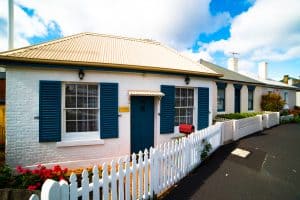
Battery Point was settled in the early 1800’s, and has retained the winding streets, colonial architecture and historical ambiance that make it one of the most fascinating historic precincts in Australia.

Built on a point of land jutting into the Derwent River, it has become one of the most fashionable suburbs of Hobart, all the while keeping its historical links with Tasmania’s past.

Things to Look for

Salamanca Place

Salamanca Place is the northern edge of Battery Point. Look for Castray Esplanade and Salamanca Place at the top of the Map of Battery Point.

Kelly’s Steps

Zoom in and you will find Kelly’s Steps. They run from the Southern end of Salamanca Place and provide a cut through to Battery Point proper. This walking tour of Battery Point will start at Kelly’s Steps.

Hampden Road

The main street running from Sandy Bay Road to the end of Battery Point is Hampden Road. Some great restaurants are in Hampden Road, perhaps the best Italian Restaurant in Australia is to be found at Da Angelo. This is Italian food from someone who really knows what he is doing.

Battery Square

Battery Square was where the gun emplacement from which Battery Point got its name was housed. It is a great place to watch the finish of the Sydney to Hobart Yacht Race. Take a picnic and enjoy the view.

Arthur Circus

Tucked away in between Hampden Road and Runnymede Street, Arthur Circus Park is a circle of early Battery Point history. Walk through for a real feel of the scale and dimensions of the cottages in old Hobart Town from the early 1800’s.

Narryna Heritage History Museum

About 100 metres from the Sandy Bay Road and Hampden Road corner, the Narryna Heritage Museum is housed in the old colonial building from which it got its name. If you are into heritage and history, Narryna is well worth a visit.

Book Yourself Booking Concierge Tasmania Australia Concierge Booking Email Search Top